
English| EUR
Suggested for you
More currencies
Choose a language
The rock chutes in El Yunque's rivers were polished by centuries of moving water, not poured by a contractor — and the walk in decides how the day goes. This el yunque water slide hike guide sets out what the terrain actually demands: footing, gradient, river crossings and water level. It also flags the conditions under which a swimmable pool becomes a hazard.
Quick answer
Reaching El Yunque's natural water slides is a short but demanding scramble rather than a graded walk: expect wet bedrock, root-laced descents and unavoidable contact with the river. The forest along PR-191 is open daily, 08:00–17:00, with free entry, so the limiting factors are daylight and water level rather than access. After heavy rain, the chutes should be skipped entirely.
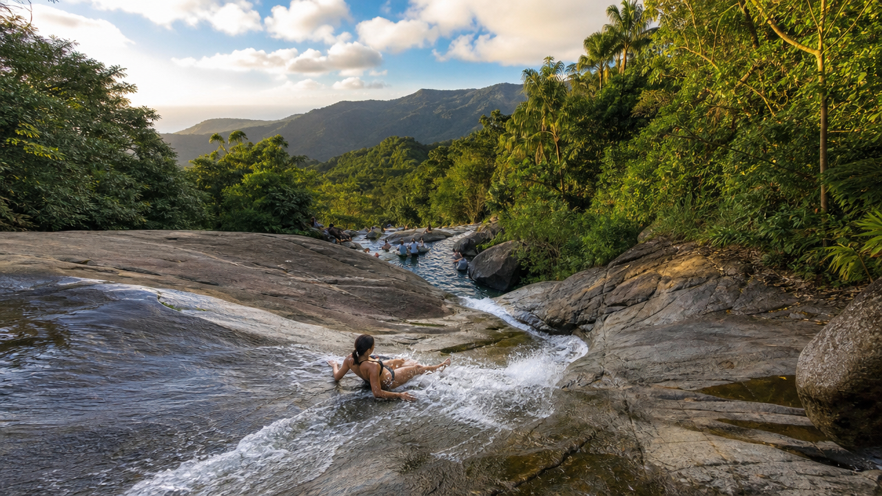
El Yunque's water slides are geology, not engineering. The chutes are volcanic bedrock, scoured smooth over centuries by rivers falling from ridges above 1,000 metres to the coastal plain in a matter of kilometres. That gradient governs the El Yunque water slide hike from start to finish. Rain on these upper slopes is measured in metres per year, and much of it arrives in short, heavy bursts that never reach the parking areas below. A creek that runs clear and knee-deep at breakfast can turn brown and chest-high by mid-afternoon, with no storm visible from where a swimmer is standing. Water level, not distance, is the variable that decides whether a day works. The approaches are short by mountain standards and harder than their length suggests. Trails off PR-191 and the surrounding secondary roads descend through tabonuco and sierra palm forest on wet clay, exposed roots and loose river cobble, often without handrails or steps. Sections that look like a path in dry photographs behave like a slide themselves after an overnight downpour. Route-finding matters too: the best-known chutes sit on rivers such as the Río Mameyes, and the last stretch to the water is frequently an unofficial scramble down a bank rather than a maintained trail. Anyone comparing this with the paved walk to La Mina Falls or the stairs at Yokahú Tower is comparing two different kinds of outing. Grip, balance and a tolerance for getting wet count for more than fitness. Conditions in August sit at the wet end of the year, when afternoon convection builds over the peaks almost daily and river levels rise fastest between roughly midday and dusk. Mornings are the calmer half of the day, and the forest's single daily window — the same 08:00–17:00 pattern seven days a week — leaves little margin for a late start. Sunlight fades early under a closed canopy, and a slick descent done in flat light is a different proposition from the same ground at nine in the morning. Local visitors call the smoothest chutes la resbaladera, and treat them as a river feature rather than a fixed attraction: some days they are a pool, some days they are a hazard, and the difference is not always announced. The practical response is to treat the outing as a river trip. Closed-toe shoes with real tread, hands free, a dry bag for phones, and a willingness to turn back are worth more than any gear list. Groups should stay within sight of one another on the descent, check the water's color and speed before anyone enters, and never enter a chute head-first or when the flow is pushing debris. Cell coverage in the valleys is patchy, so someone outside the forest should know the plan. Visitors who want the route read for them — river level, entry point, exit — often book a guided El Yunque water slide hike with a licensed operator, which removes the guesswork about which pools are running safely on the day. Details for the forest itself, including the office line on (787) 888-1880, sit with the U.S. Forest Service.
“Water level, not distance, is the variable that decides whether a day works.”
This procedure walks you from the PR-191 trailhead to the natural water slides, following the markers that keep you on route where the path braids and drops toward the river. Allow roughly 45 to 90 minutes each way depending on how often the trail is wet underfoot.
Start from the signed trail access along PR-191 in Río Grande, where a wooden Forest Service marker names the trail and gives distances. Hikers often set off from the first pull-out they see rather than the signed entrance, which puts them on a service road instead of the trail.
The first stretch is a narrow paved or concrete-slab path descending under closed canopy. Stay on the slab even where dirt shortcuts appear to cut the switchbacks — those cuts dead-end in dense vegetation and cost more time than they save.
Once the sound of moving water is audible, keep the river on your left and continue downstream. Losing the water sound usually means you have drifted onto a side spur climbing away from the drainage; backtrack until you hear it again.
A cluster of large grey boulders with a worn footpath between them marks the turn toward the water. Walkers frequently pass this junction because the main path continues visibly straight ahead — the correct route is the narrower branch dropping right.
Use the exposed roots and rock ledges as handholds on the final short descent to the slide pools. Face the slope rather than walking down forwards, and test each root before committing weight to it.
Return by the identical path rather than following the river further downstream. Downstream routes lead into private land and unmaintained terrain with no marked exit back to PR-191.
Most injuries on the hike to El Yunque's natural water slides come from a handful of repeatable errors, not from bad luck. The list below covers the safety failures that send visitors home with sprains, cuts, or worse.
Hiking in after heavy rain upstream
Check the sky and the water colour before descending: brown, fast-moving water means a flash flood is possible even under clear skies where you stand. Turn back and wait for the river to run clear.
Wearing flip-flops or smooth-soled sneakers
Use closed-toe shoes with lugged rubber soles that you accept will get soaked. The river rock is coated in algae and behaves like wet tile under smooth soles.
Jumping into pools without checking depth first
Never enter feet-first from height into water you have not inspected. Depths shift after every storm and submerged boulders sit inches below the surface.
Overestimating fitness on the steep return climb
Treat the walk back uphill as the hard half and budget energy for it. If the descent already left your legs shaking, stop at the first pool rather than continuing.
Scrambling off-trail to reach a lower cascade
Stay on the established path and marked river access points. Unofficial cut-throughs cross loose volcanic soil and drop-offs hidden by vegetation.
Hiking alone with no one told the plan
Go with at least one other person and leave your route and return time with someone off-trail. Mobile signal is unreliable through most of the river corridor; ranger assistance is at (787) 888-1880.
The best arrival window is 08:00–09:00 to ensure parking access and secure time on the trail before peak congestion. Monitoring weather patterns is essential, as heavy rainfall can trigger flash floods in the river areas.
—
Fewer visitors allow for easier navigation of the trail and water slide entry points.
Low rainfall, 70–80°F
Lower humidity and less frequent rain decrease the risk of sudden river water level rises.
High humidity, 75–85°F
Frequent afternoon showers increase the likelihood of hazardous flash floods near the natural slides.
Verdict: Tuesday to Thursday, arriving between 08:00 and 09:00, during the months of February through April provides the optimal balance of lower crowds and safer river conditions.
El Yunque National Forest operates on a consistent schedule throughout the week to provide access to the rainforest trails and natural water slides.
Access to the natural water slides within El Yunque National Forest is available at no cost. A separate admission fee applies only if you choose to visit the El Portal Visitor Center.
Verdict: A typical adult pays 0 USD for forest access, with the only additional cost being the 8 USD fee if visiting the El Portal Visitor Center.
Everything you need to know about el yunque water slide hike
The trek to the natural water slides is considered moderate, involving uneven terrain, muddy paths, and slippery rocks near the riverbed. Hikers should be prepared for a humid environment and require sturdy footwear with good traction.
Safety is paramount when visiting these natural features; always observe water levels and avoid the area during heavy rainfall to prevent flash floods. Visitors should never attempt to slide if the current is strong or the water is murky.
To ensure access before parking capacity is reached, plan your el yunque water slide hike arrival between 08:00–09:00. This early window helps avoid the largest crowds and potential entry delays at the forest gates.
There is 0 USD entrance fee for general access to the forest, though the El Portal Visitor Center charges 8 USD per adult. This means you can enjoy the natural attractions of the rainforest without paying a specific permit fee for the trail itself.
While children can participate, it is highly recommended they be strong swimmers and supervised closely at all times due to the unpredictable nature of the river. Parents should assess the current trail and water conditions personally before allowing minors near the slides.
Essential items for your outing include water shoes with excellent grip, a dry bag for electronics, plenty of drinking water, and insect repellent. Bringing a towel and a change of clothes is also recommended for your return trip.
The trailhead for the popular el yunque water slide hike is located at PR-191, Río Grande, 00745, Puerto Rico. It is best to use a GPS-enabled map service to locate the specific turn-off points, as signage can be sparse in certain sections of the forest.